FlatCITY
The UN Convention on the Rights of Persons with Disabilities emphasizes accessibility as a fundamental principle. States commit to promoting new technologies for individuals with disabilities. Smart Cities leverage information and communication technologies for inclusive navigation. A holistic approach must merge software and hardware sensors to seamlessly detect and address barriers for individuals with diverse abilities, utilizing geographic information, LiDAR, sensors, social networks, and user-contributed data. The FLATCity project (opens new window) (grants TIN2016-77158-C4-1-R, TIN2016-77158-C4-2-R, and TIN2016-77158-C4-3-R) addressed identified gaps in smart city technology. It focused on developing a versatile technology enabling any smart city to create personalized, barrier-free mobility assistants. The technology constructed layers of information on urban elements impacting user mobility. It gathered data from open internet sources, geomatic sensors (like LiDAR sensors), and employed crowd-sensed data from hardware and software sensors carried by citizens (e.g., accelerometers, gyroscopes, barometers, light, and sound sensors). This included traces left on the internet, such as social network activity.
The main objective in this proof-of-concept project is to increase the knowledge and the results obtained in the FLATCity project to confirm their innovative potential and facilitate their transfer to the productive sector. To achieve this objective, we must perform the following activities:
- Continue with the development of the existing components to make them robust, reliable and to create a system that can be used in real environments.
- Establish contacts with public administrations (in particular, municipalities) and with companies (in particular, software development companies and engineering companies) to organize a proof-of-concept of the system to determine the technical, commercial, and social viability of the system.
- Protect the industrial property rights of the system and determine a roadmap to manage and exploit the system in the future.
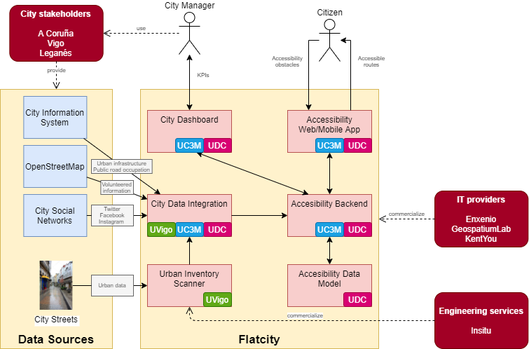
The following figure shows our vision for this project. We foresee an information system that targets four groups of stakeholders: the government of a city that provides a new service to the citizens, the IT providers that commercialize and operate the system, and the engineering providers that commercialize the service of scanning the city streets to build the urban inventory. The left side of the figure shows the data sources that we are going to consider in this project. The first one, which was not considered before, is the existing city information system that must provide information regarding the urban infrastructure (e.g., streets, disabled parking spaces), and the public road occupation (e.g., sidewalk blocks due to construction works). The second one is OpenStreetMap that will be used to complement the information provided by the city information system. The third one is Twitter that will be used to collect information regarding obstacles in the city. Finally, the fourth one is the actual city streets that will be scanned using mobile laser scanners to collect information about the urban inventory.

The FLATCity project is funded by the call for grants for R&D&i Projects for the realization of "Proofs of Concept" 2021, which aims to promote and accelerate the transfer of knowledge and results generated in research projects under the State Plan. The project is being carried out by three research groups.


FLATCity-Board: Backend and Dashboard for FLATCity
PDC2021-121239-C31
+ info


FLATCity-Urban: Urban Inventory for FLATCity
PDC2021-121239-C32
+ info


FLATCity-App: Mobile Application for FLATCity
PDC2021-121239-C33
+ info

